
A Pass, A Peak, A River and A Valley


It's August 16th, and once again a couple of weeks have slipped by without an update, a state of affairs attributable in equal measure to my sloth and the very, very, very poor internet connections available in Leh.
Since I last wrote, we've made a few outings from Leh: up the Khardung La, a climb of Stok Kangri, a river rafting trip and a 4-day trip to the Nubra Valley. In the process, we've almost used up our allotted time here in Leh, and either tomorrow or the next day should see us riding towards Srinagar and the end of the bike trip. We've all lost weight over the past few weeks, and some of us (Audie and I) are starting to look a bit skeletal, particularly in the face. Must eat more.....
After a couple of days of well-earned rest and recuperation in Leh after our Panggong Lake trip, we set off on August 6th for a day trip up what the Indians claim is the highest road pass in the world. For centuries, up until 1950, this pass was the first of 5 major passes leading from Leh to the city of Yarkand, in what is now Xinjiang province in China. Seven years ago, while cycling from Pakistan to Tibet, Audie, Saakje and I rode over the first two of these passes coming south from Yarkand. It provided a bit of a historical context for the ride, other than it being allegedly the highest pass on earth. It was fun to imagine caravans of horses, ponies and Bactrian camels toiling up the pass, laden with cotton goods and opium (India's major exports to China in the 19th century), or coming down into Leh carrying silver ingots, hashish and fine toosh and pashmina wool. It certainly helped pass the long, tough hours of climbing.
Since it was a day trip, we left behind all our luggage and rode our unloaded bikes, which was a treat. From Leh, at 3600 metres, we expected a 2000-metre vertical climb to 5602 metres at the crest of the pass. It was a cold, cloudy day, and fresh snow dusted the pass in front of us as we rolled out at 7:30 am. It was certainly a rare luxury not to have any extra weight to propel up the pass, and Reini, Audie and Saakje set a fierce early pace. I was still not acclimatized to altitude, despite being at altitude for two and a half weeks, and I fell behind as I stopped periodically to pant for breath. The road climbs relentlessly for 43 km at an average gradient of 4%, rising in endlessly coiled switchbacks up the bone-dry barren hillsides. We could look back at the green splash of Leh oasis sloping down toward the Indus, and beyond that to the glaciated peaks of the Stok Range, which were covered in cloud.
The road was in reasonable condition as far as the road-maintenance camp of South Pullu, 14 km from the top, but after that the rigours of long, snowy rivers, snowmelt, landslides and heavy truck traffic turned the road into a potholed dirt track. I bumped along slowly, through intermittent snow flurries, chatting with a Dutch cyclist, and finally reached the windy summit of the pass around 2:00, having spent five and a half hours in motion and, apparently, an hour sitting beside the road on various breathers. Reini and my sisters had been waiting for nearly an hour, so we didn't linger too long at the top, just long enough for the obligatory photos and to check the altitude on our altimeters. At 5300 metres, the altitude was a full 300 metres lower than the claim by the Indians. Not only is the Khardung La not the highest pass in the world, it's not even the highest pass in Ladakh! According to our altimeters, as well as those of most other cyclists who have ridden the Khardung La, it's about the same height as the Taglang La (on the Leh-Manali road) and about 50 metres lower than the Chang La (on the Panggong Lake road). As well, none of these Ladakhi passes are as high as the pass from the Aksai Chin plateau into Tibet on the Kargalik-Ali road in China. We felt cheated, but at least we knew that we had ridden those higher passes as well. The descent was a joy, hurtling down at 40 km/h, back to a late, well-earned lunch in Leh.
The next day saw us heading off by jeep to Stok, a small village directly across the Indus from Leh. We were carrying big backpacks, ice boots, crampons and ice axes, since we were off mountain climbing. Stok Kangri (6050 m; again the Indian government claims some non-existent extra height, giving an altitude of 6121 m) is the highest peak in the Stok Range, the snowiest and most glaciated stretch of the Zanskar Range, to the south of the Indus River. Most climbers hire a guide and ponies to carry their gear, but we wanted to be self-supported, so we lugged everything on our backs.
The first day's walk was pleasant, gently uphill along boulder-strewn riverbeds, past more of the "stegosaurus graveyard" geology we had seen while cycling: vertical strata eroded into spiny shapes between softer layers. It was a rude shock to the body to be carrying so much weight, and I was still unacclimatized, so I lagged a bit behind the others. We had set out late in the day, and we soon discovered the disadvantage of not having a guide; we had no idea which way to turn at valley junctions. The guide for an Israeli group set us right the first time we made a wrong turn, and another time we had to flop down on the ground to wait for the Israelis so that we knew which way to go. We camped just short of the usual campground, which we had been told was full, played guitar and harmonica and slept well, lulled to sleep by the babbling of the nearby stream. Just as we were turning in, an old Ladakhi herder came by and demanded money for allowing us to camp there. Since all she could say was "sleep camping", we were worried at first that she wanted to sleep in our tents! It was quite a relief to know that she was just trying to extort money from us.
The next day was, we knew, a very short one, so we slept late and lounged around as Saakje tried to cook bannock (native Canadian bread) on our stoves. It didn't really work (our pots and pans are too thin, so the bannock burned to the bottom), but it was a nice change in our diet. At noon, we finally set off, arriving at base camp, some 700 metres higher, at 2:00. We set up camp and walked higher up the mountain to scout out the route for the next day before turning in early.
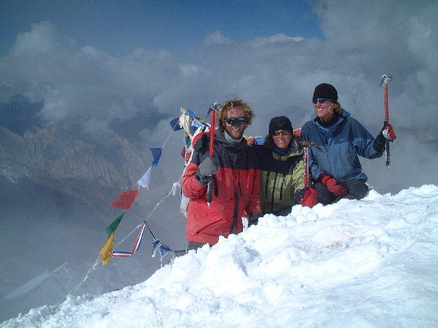
It was a short, restless night in the tents. It snowed several times during the night, waking us up every time, and by 1 am climbers were getting up and setting off. Not keen on climbing in the snow, we went back to sleep, but by 3 am the weather seemed to be improving and I lashed everyone out of their tents and onto the trail by 3:45. The freshly-fallen snow made it easy for us to follow the tracks of the previous climbers, and out on the glacier, we began to catch up to them. We climbed steeply up a snowy slope, without crampons but relying heavily on our ice axes for balance. We then angled across the steep face of the mountain to a steep, corniced ridge which we followed to the summit, trying not to lose our footing and plummet a few hundred metres downhill. Again, I lagged behind the others and arrived at the summit about an hour behind them, at 9 am. Most of the climb was in thick fog, but as we sat at the summit, the clouds parted to the south, affording us a view of the Markha Valley and the Great Himalaya range behind. More spectacular was the nearly vertical glacier at the head of the valley we had climbed, a perfect piece of ice sculpture.
The descent was rather fun, at least after the hair-raising descent of the ridge. I put my crampons on for this bit, and promptly cramponed myself in the back of the leg, shredding my pants and long underwear but miraculously not puncturing the skin. After that, it was a fun sliding, slithering descent in the heat-softened wet snow. To be more precise, it was fun for Reini and me, but Audie and Saakje found themselves escorting two altitude-sick Israeli women down, which took forever as they were very high-maintenance types who drove Audie and Saakje mad with frustration.
By noon we were back in base camp, sipping tea and feeling a bit tired from the 1150-metre climb, the altitude and the sleepless night. Audie and Saakje, however, were keen to get back to Leh, so we packed up camp and trudged downhill for four endless hours. By the time we got to Stok, Reini and I had blistered feet, and I felt as though I'd been through an interrogation at Guantanamo Bay. We caught a bus to Leh, and arrived back at our guesthouse to find that there were no rooms, we were too late for a shower, and we had to pitch our tents in the garden. Hardly the triumphant homecoming we had wished for.
After another lazy day in Leh, we went for a day of whitewater rafting on the Indus. We had been told that we were up for some class 4 rapids, but it was a pretty placid stretch of river, other than 2 decent rapids near the beginning and end. It was, however, a relaxing new perspective on the Indus, and we had a wonderful lunch in the sunshine of an apricot orchard after the rafting. The drive back confirmed our fears that the first day of riding towards Srinagar, rather than being an easy coast downstream on the Indus, is going to be a day of big climbs and descents in the bone-dry desert west of Leh.
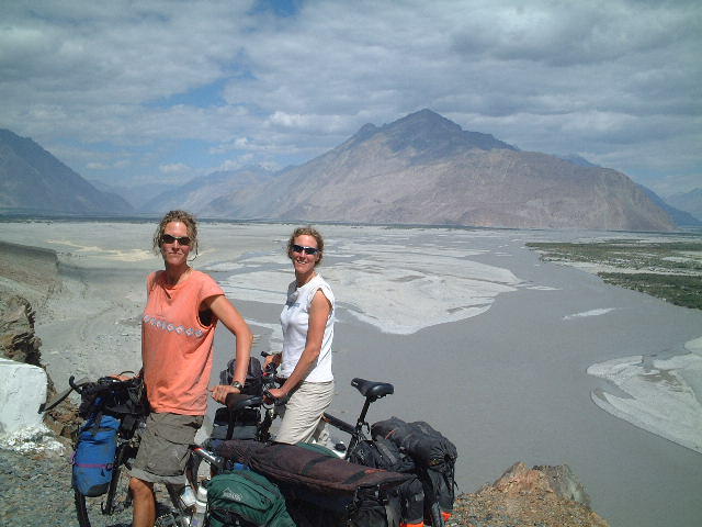
On the 12th, with my sore legs from the Stok Kangri descent almost recovered, Audie, Saakje and I set off for a bike trip to the Nubra Valley; Reini decided to stay in Leh and relax. This represented a change of plans for us, as we had originally wanted to go trekking, but the lure of bigger mountains and grander vistas changed our minds. The Nubra Valley, to the north of Leh, lies on the other side of the Khardung La, necessitating crossing the monster pass a second time. In order to save time and effort, since we had already climbed the pass once, we decided to take a taxi to the top and start riding downhill. It took forever to find a taxi willing to take three bikes inside; for some reason most Indian-made cars don't have seats that can be folded down or removed. After a great comedy of errors, we got the bikes loaded and set off. When we got to South Pullu, we found, to our chagrin, that the road was closed to uphill four-wheeled traffic and that we had to pedal the final 14 km of the climb again.
Gritting our teeth, we unloaded the bikes and started riding. It was a completely different experience this time, however. We all seemed to be perfectly acclimatized, at long last, and the weather was cloudless and warm. We pedalled up the pass almost effortlessly and soon enough we were back at the top of the "Not Even the Highest Motorable Pass in India, Let Alone the World". The ease of cycling was partly due to not taking camping equipment with us, but mostly, especially for me, it was because we could finally do exercise at high altitude without panting and gasping for oxygen in the thin air. The descent was perfect: great road surfaces and a wide-open vista of badlands, canyons, irrigated oases and the vast glaciated peaks of the Karakoram in front of us. We descended nearly 2000 vertical metres into the valley of the Shyok river (a major tributary of the Indus) and put up for the night in a small truck stop in Khalsar where we ate some of the best dal bhat (rice and lentils) of the trip and played cards late into the night.
The next day we rode a grand total of 22 km to the village of Diskit, where we found a spotless, well-run guesthouse (truly a rarity in these parts), dumped our bikes and took to our heels through the sand dunes that fill much of the broad, dry Shyok valley. In true XTreme Dork fashion, we ended up in a swamp at our first attempt, but we perservered and found some lovely small dunes and even a few two-humped Bactrian camels, although they were being used to ferry package tourists around. It was a lovely break from cycling and a pretty area. We felt confined, however; much of Ladakh is an off-limits military zone, and while we could gaze at interesting-looking valleys emerging from the Karakoram, we were forbidden from exploring them. Ladakh is far harder to explore than the Northern Areas of Pakistan, where, with a few exceptions, every valley is open to hiking. This feeling of confinement, along with the fact that virtually all trips in Ladakh have to be out-and-back, rather than one continuous path without backtracking, makes Ladakh a less appealing destination overall than Nepal, northern Pakistan or Tibet, at least for bike tourists.
The last two days were devoted to climbing back out of Nubra. The first day's climbing was easy, made easier by spending the entire climb on ethical debates and word games like Just a Minute and Metaphors. We stayed in a "tea hotel" that turned out not to be a hotel; we were put up in the bedroom of an unfortunate son of the family. The next day, we climbed the rest of the way to the top of the Khardung La on India's Independence Day, with essentially no traffic all day. That makes 2.5 times that we've climbed the Khardung, and I think that's enough for anyone's lifetime. After another fun freewheel down into Leh, I collapsed into bed for 11 hours of well-earned sleep while Audie, Saakje and Reini went out for celebratory beers. Since Independence Day is marked by 3 days of Prohibition, they had to drink furtively at our favourite restaurant, La Pizzeria, where the waiter brought pot after pot of "ice tea", to be drunk out of teacups.
So now it may be our last day in Leh, with its dangerous drivers, imported beggars, excessive numbers of cycle tourists and overcrowded accommodation. The Lombardy poplars which line the oasis started to shed their fluffy seeds yesterday, and everything is covered in a layer of snowy white fuzz. I think that tomorrow we will start our ride to Srinagar, which should take about 7 days. This depends a bit on the Dalai Lama, who is coming to Choglamsar, 7 km from here, tomorrow. If he is making a public appearance tomorrow morning, we may stay for that. If not, it's off to the medieval frescoes of Alchi Monastery, the unusual Buddhist Dardic culture of the Dha area, the dour Muslims of Kargil and finally the Zoji La and the long downhill into Srinagar and its houseboats.
Until the next update, I remain
Yours Acclimatizedly
Graydon
posted by xuanzang @ 10:24 PM
![]()
![]()
<< Home